![](/images/other/stat-length.png)
![Randonnée Marche Gemeinde Brandenberg - La Voie de l’Aigle : J3 - Photo](https://media.geolcdn.com/t/1900/400/3c2428e9-612e-490c-92fc-1d25fa4e2f54.jpg&format=pjpeg&maxdim=2)
La Voie de l’Aigle : J3
Greg813
Utilisateur
![Longueur](/images/other/stat-length.png)
Longueur
22 km
![Altitude max](https://static1.geolcdn.com/siteimages/upload/files/1508320355ic_sort_altitude_max_24dp.png)
Altitude max
1895 m
![Dénivelé positif](https://static1.geolcdn.com/siteimages/upload/files/1508320355ic_sort_den_pos_24dp.png)
Dénivelé positif
1450 m
![Km-Effort](/images/other/stat-length.png)
Km-Effort
38 km
![Altitude min](https://static1.geolcdn.com/siteimages/upload/files/1508320355ic_sort_altitude_min_24dp.png)
Altitude min
673 m
![Dénivelé négatif](https://static1.geolcdn.com/siteimages/upload/files/1508320355ic_sort_den_neg_24dp.png)
Dénivelé négatif
608 m
![Boucle](https://static1.geolcdn.com/siteimages/upload/files/16400158638029165_repeat_loop_refresh_sync_direction_icon.png)
Boucle
Non
Date de création :
2022-07-31 06:29:59.03
Dernière modification :
2024-09-15 07:26:34.561
![Marche](https://static1.geolcdn.com/sitytour/trail-icons/101.png)
6h18
Difficulté : Difficile
![Scannez ce code QR pour ouvrir la randonnée dans l'application SityTrail](https://capi.geolives.com/qq0zvz2zws4bq2lad0pu/sitytour/trails/3337888/qr.png?size=200)
Application GPS de randonnée GRATUITE
À propos
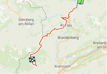
Randonnée Marche de 22 km à découvrir à Tyrol, Bezirk Kufstein, Gemeinde Brandenberg. Cette randonnée est proposée par Greg813.
Description
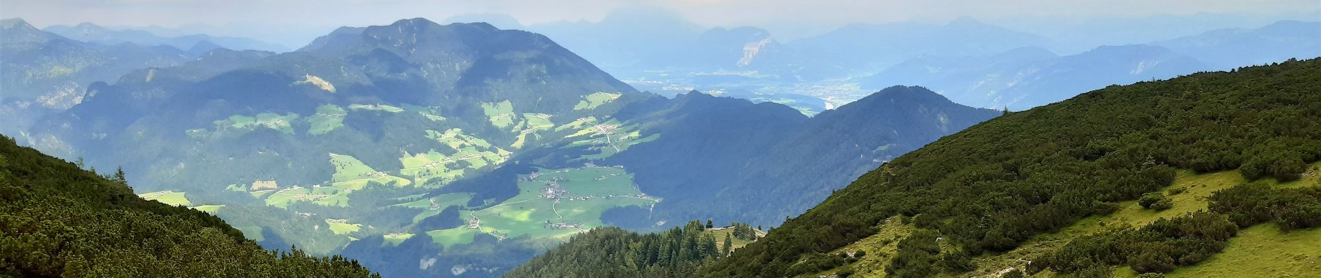
Trek de 8 jours dans le Tyrol autrichien avec Mettons le Monde en Marche. Parcours de la voie de l'Aigle de Langkampfen à Innsbrück avec nuits en refuge.
Etape 3 : Pinegg – Münster
Pour d'autres photos, voir le site de l'association :
https://mmm-rando.org/trek-la-voix-de-laigle-autriche-2022/
Localisation
Pays :
Autriche
Région :
Tyrol
Département/Province :
Bezirk Kufstein
Commune :
Gemeinde Brandenberg
Localité :
Unknown
Départ:(Dec)
Départ:(UTM)
719258 ; 5268935 (32T) N.
Commentaires
Randonnées à proximité
![Randonnée A pied Gemeinde Brandenberg - Wanderweg 16a - Photo](https://media.geolcdn.com/t/375/260/bdf829e0-0c62-45ea-94dd-d26700d65d81.jpeg&format=jpg&maxdim=2)
![A pied A pied](https://static1.geolcdn.com/sitytour/trail-icons/100.png)
Wanderweg 16a
A pied
Facile
Gemeinde Brandenberg,
Tyrol,
Bezirk Kufstein,
Autriche
![](/images/other/stat-length.png)
4,1 km | 6 km-effort
1h 21min
![](https://static1.geolcdn.com/siteimages/upload/files/16400158638029165_repeat_loop_refresh_sync_direction_icon.png)
Non
![Randonnée A pied Gemeinde Brandenberg - Wanderweg 16 - Photo](https://media.geolcdn.com/t/375/260/bdf829e0-0c62-45ea-94dd-d26700d65d81.jpeg&format=jpg&maxdim=2)
![A pied A pied](https://static1.geolcdn.com/sitytour/trail-icons/100.png)
Wanderweg 16
A pied
Facile
Gemeinde Brandenberg,
Tyrol,
Bezirk Kufstein,
Autriche
![](/images/other/stat-length.png)
4,3 km | 6,3 km-effort
1h 25min
![](https://static1.geolcdn.com/siteimages/upload/files/16400158638029165_repeat_loop_refresh_sync_direction_icon.png)
Non